In the Internet Age, monoculture is unachievable. But there remain a few things that we can all agree on. The Ringer is looking at this rarefied group all week. These are our Undeniables.
Google Maps software engineer Andrew Lookingbill still remembers the night he and his teammates got lost. It was about a year after he joined Google in 2007 that the core team decided to escape from the Mountain View, California, campus, pile into a car, and drive to downtown San Jose for dinner.
“At this point we’d been working on building the U.S. maps for some time,” Lookingbill recently told me. “We kind of thought we knew what we were doing.”
The company’s now-ubiquitous app, which allows drivers to follow turn-by-turn directions and real-time traffic updates, had not yet been released. So, naturally, they got a little turned around.
“We were sitting there kind of parked under an overpass, arguing about how to get back to the block with the restaurants on it, when it really dawned on us that, when you say you’re going to make a map of the country, it means you’re trying to get it all right,” he said. “Every road name, every turn restriction, every address, every building. Every single one of those that you mess up could wreck somebody’s day. It was incredibly sobering.”
At that moment, Lookingbill and his team felt something like the weight of the world on their shoulders, because, ostensibly, it was their job to map it.
These days it’s hard for most people to imagine a dinner outing, road trip, bike ride, train ride, bus ride, or stroll happening without first consulting Google Maps. But now it does so much more than get you from Point A to Point B. The software has helped people scout vacation spots, reunited at least one family, documented and solved crimes, generated ghosts of our loved ones, and become an inadvertent source of (often disturbing) photojournalism. (Unfortunately it also has allegedly led a couple to drive off a decrepit bridge, which if anything, only demonstrates society’s dogged reliance on it). We’ve all plugged in an old address — a childhood dwelling, college digs, our first adult apartment — to revisit a past life via Street View, the closest we can actually come to walking down memory lane sans a plane ticket. Without realizing it, the modern-day digital cartographers at Google Maps have given us a new way to navigate our existence as humans, to capture and revisit the geographic nodes of our lives.
Google Maps began as Where 2 Technologies, a C++ program by an Australian company that was designed to allow people to download individual maps. (If you want to know more about those early days, an incredibly precocious 13-year-old journalist named Ruby Cogan has, by far, the most thorough account). Google bought the company in 2004, alongside a geospatial data visualization startup (which would later become Google Earth) and a business that offered real-time traffic analysis. The following year, a digital map that allowed you to “click and drag … dynamically,” as the inaugural blog post put it, was born.
Anyone who remembers the infamous Saturday Night Live digital short “Lazy Sunday” also knows that by 2006, Google Maps was already on equal standing with competitors like Mapquest and Yahoo Maps. (Even then, Andy Samberg declared it “the best.”) But it was not until the launch of “project Ground Truth” in 2008, an ambitious initiative led by a core team of roboticists, that it pulled ahead to become one of the most essential digital tools of our age.
When Maps first launched, its interface and step-by-step directions were based on existing data from sources like municipal records and satellite imagery. But that information would sometimes be out of date, inaccurate, or lack the specifics that a human being would need to actually navigate an area. Project Ground Truth aimed instead to gather its own information — focusing on details that would be most helpful to its customers — and to create a semi-automated process to cross-check that data with existing records. This plan was inspired by the launch of Street View a year earlier, when engineers realized that the photos they captured could also be used as an ultra-efficient way to comb through and tag certain markers, like street numbers painted on curbs, traffic signs, speed limits, or the names of businesses. Ultimately, this image processing became the groundwork for the endlessly helpful turn-by-turn directions that most drivers, bikers, and pedestrians would be lost without today.
To ensure their maps were as complete as possible, the team adopted a steady and focused workflow — the opposite of the “move fast and break things” mantra popularized by Silicon Valley’s incessant experimentation. Their model for collecting information developed slowly as the team began mapping in Portland, Oregon, moved its way through the United States, and then began hopping from country to country. Under the leadership of computer scientist Sebastian Thrun, who later led the launch of the company’s self-driving car division, they broke the mapping up into tenable, tractable pieces that were defined by the scope of “next week” or “next month” rather than “South America” or “Everything that touches the Pacific Ocean.” All the while, Google ensured mistakes were quickly fixed by employing a small group of human operators to field the tens of thousands of complaints reported by users each day (Sample: “There’s a field of marijuana here, please call the cops.”).
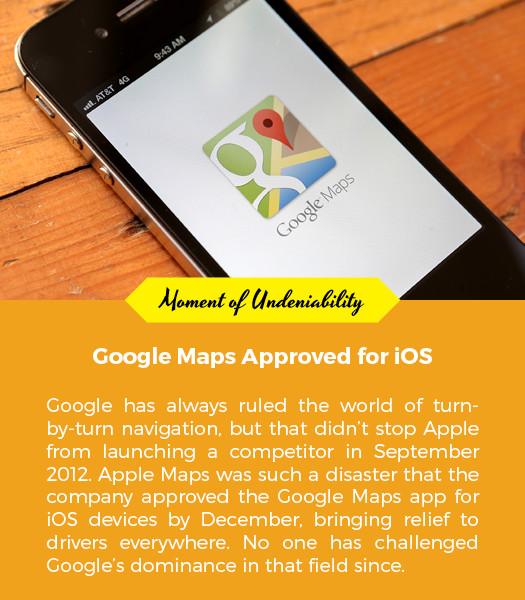
The Maps team’s meticulous documentation didn’t really proved itself indispensable, though, until the Great Digital Cartography Battle of 2012. With the premiere of iOS 6, Apple chose to unceremoniously dump Google Maps as a data provider for its default maps app, replacing it with information sucked from the company’s recent maps acquisition. The day it dropped, iPhone owners dragged the company across the internet. The app’s search abilities were archaic, it lacked public transit directions, and its Earth view imagery was warped like a Dalí clock. Tim Cook made a public apology, higher-ups were fired, and Change.org petitions began popping up, begging Google to build a standalone iOS app. Eric Schmidt played coy just to make Apple squirm and then — bam! — three months later, Google gave us the app. It rose to the App Store’s most popular list in a matter of hours, like a Beyoncé album. It eclipsed Apple’s attempt at a challenger.
Just as the Maps team obsessed over making its experience as human-oriented as possible, its mobile version was designed, as Lookingbill put it, “to get out of the way and just save our users time in ways we weren’t even aware of.” Considering both Maps employees’ personal travel experiences and the breathless grunts we, the garbage internet, type into the Google search engine, they created a system that offers logical results to almost nonsensical queries.
As a result, we now expect the app to do more for us, with even less context. A long time ago, according to Lookingbill, people might search for something like “restaurants san francisco.” Today, it’s “restaurants in chinatown that stay open past 10pm.” “People are asking their phones ever harder questions,” Jen Fitzpatrick, a VP at Google Maps, recently told Elle.
It’s already amazing to have free access to a product whose exhaustive information is as close to infallible as possible. But an app that’s so dependable, so trustworthy, so intuitive that it inspires us to ask for more? That’s undeniably great.